
The UK is set to be hit by more thunderstorms and rain as unsettled weather continues.
Torrential rain and a “spectacular electrical storm” lashed parts of the country overnight and stormy weather is set to return on Wednesday evening, according to The Met Office.
It said there were still showers and thunderstorms anticipated during rush hour but that there would be bursts of sunshine in the west when cloud breaks.
Met Office data shows the showers sweeping most of the UK particularly in the South East, North East, Scotland and Ireland.
Homes were left without power and roads were flooded in parts of the South East, while Lenham in Kent saw 1.7in (42mm) of rain in the space of just one hour.
The Met Office said the deluge in the village – which lies between Maidstone and Ashford – came between 11pm on Tuesday and midnight, with just under the average rainfall for the whole month of June in an hour.
Images and video on social media captured spectacular lightning in the skies over the region and the moment a power cut took place, while Kent Police’s Roads Policing Unit tweeted that the lightning was “very active”.
The Met Office said there were 41,000 “cloud to cloud” lightning strikes over the UK sea, northern France and Low Countries overnight. Some 358 of those were from clouds to the ground over the UK.
#Lightning #UK Well impressed with what a normal person like wot I am, can do with a slow motion feature on his mobile phone. #Kent #Weather pic.twitter.com/GyhPNzwhNI
— Motorcycle Biker UK (@MBikerUK) June 19, 2019
Eastbourne in East Sussex is said to have seen about 1,000 lightning strikes in an hour.
UK Power Networks was unable to specify how many homes in the area had been affected by brief power cuts but said it was “several thousand”.
Sussex Roads Policing team described it as a “spectacular electrical storm” over East Sussex but warned of “significant flooding” on the A27 and A259 between Lewes and Hastings, adding: “Power cuts also knowing traffic lights out: please take care.”
Ben Williams, 31, who filmed the storm in Ticehurst, East Sussex, said: “It was full-on, pretty much constant flashes of lightning and thunder at its peak. I’ve not seen a storm like last night’s in the UK before.”
This storm is mad 😮😍 #brightonstorm #weather @brightonargus @BBCSussex pic.twitter.com/hhGO7EJcCv
— Adam Coffin (@Coffdrop17) June 18, 2019
Susan Pilcher said: “It was possibly the most amazing storm I have ever watched. I had seen lightning in the back garden and decided I had to go to Dungeness to watch it as it is so open there.
“I stayed from about 11pm to 1.30am with sheet lightning and fork lightning chasing across the sky and heavy, heavy rain at times. Very exciting.”
@LondonSnowWatch @TheSnowDreamer @KentStormChaser @Kent_Online @JAclouds @enjoyscooking @atxwxgirl @ajsg @barnet_rebel @patriziamiani @countryboots126 @tonytewitty @clarenasir @simon_weather @JoMarie357 @jo last night in horsmonden Kent 🇬🇧 pic.twitter.com/j14lPwO6Eo
— Luke (@luketaplin42) June 19, 2019
Carol Pearce, 51, from Eastbourne, said the power cuts badly affected phone lines and WiFi signals, while floodwater had mostly drained away by the morning.
She added: “The power cut out very abruptly and, once it came on, we could see the houses opposite the quay from us go on row by row.
“When the strike hit everything went pitch black instantly with an accompanying clap as far as the eye could see across Eastbourne from our house.
“The storm hit quickly, it went from distant flashes over the Channel to a solid sheet of rain and lightning on top of us so fast we hadn’t had a chance to close all the windows in between, and the lightning and thunder were constant for 20 minutes or so, deafening loud and filling the windows on both sides of the house with white.
Slow mo video of tonight’s storm to the east of #brighton. More more more. #lightning #thunderstorm #thunderstorms #extremeweather #ukweather #natureatitsbest #metoffice #loveukweather #lovethunderstorms #hove #sussex #brighton #SlowMotionChallenge pic.twitter.com/i3hVkg0ct3
— Darren (@Dazcav) June 18, 2019
“The bolts were very visible forks, and one lasted several seconds as if it had hit something in the distance.
“The footpaths around our house were flooded within minutes of the downpour when it hit, but despite that we could still see people outside braving it.”
Luke Taplin, who saw the storm in Horsmonden, Kent, described it as “very electric” and “rather intense just after 11pm”.
A yellow weather warning is in place for thunderstorms across much of the south-east of England, including East Anglia, until 9pm on Wednesday.
Whilst #thundery showers are clearing away from East Anglia, further #thunderstorms are heading towards Sussex and Kent with some downpours likely ⛈️ A warning is in force until 21:00 https://t.co/QwDLMfRBfs #WeatherAware pic.twitter.com/ohWEPrCP4k
— Met Office (@metoffice) June 19, 2019
Forecasters say further rain, hail and lightning could bring potential disruption to travel.
“We’ve had some heavy, thundery showers overnight,” said meteorologist Alex Burkill.
“There has been some flooding near Eastbourne and some power cuts.
Mom caught the moment a lightning strike took our power out in #Eastbourne pic.twitter.com/FqeTTrMFKC
— Khemi (@KhemiEvans) June 18, 2019
“We are going to see some further heavy showers heading towards Kent, and south-east parts of the UK will see some heavy thunderstorms through the morning, while isolated ones could develop this afternoon.”
The flood-hit community of Wainfleet in Lincolnshire is within the Met Office’s warning area, but forecasters are optimistic that the town will escape the worst of the storms on Wednesday.
“A few showers are possible there, but it doesn’t look like it’s going to bear the brunt of the heavy downpours,” Mr Burkill added.
The town has already seen around 225 Olympic-sized swimming pools’ worth of water pumped out to sea following severe flooding last week.
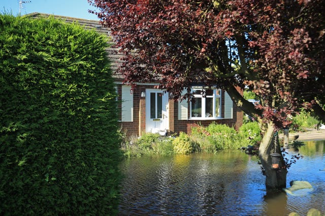
Around 350 tonnes of sand and ballast were dropped in the area by RAF Chinook helicopters over the weekend.
On Tuesday, Lincolnshire Police said almost 600 homes remained evacuated as the clean-up operation continued.
The Lincolnshire emergency team said on Wednesday that it hopes to return people to their homes by Monday.
A few more shots of the #Lightining over Sovereign Harbour #Eastbourne last night. Best lightning show in years. pic.twitter.com/mh1fqcgRQk
— Mark Jarvis (@SussexSnapper) June 19, 2019
The weekend is also set to bring some respite from the recent downpours, with temperatures rising as high as 23C (73F).


Comments: Our rules
We want our comments to be a lively and valuable part of our community - a place where readers can debate and engage with the most important local issues. The ability to comment on our stories is a privilege, not a right, however, and that privilege may be withdrawn if it is abused or misused.
Please report any comments that break our rules.
Read the rules here